Geolocate

Breckenridge topographic map

Click on the map to display elevation.

👉 Easily get elevation data in JSON, GeoTIFF and KML formats using Elevation API
Thank you for supporting this site ❤️
Make a donation

About this map

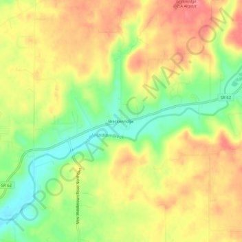
Name: Breckenridge topographic map, elevation, terrain.

Location: Breckenridge, Harrison County, Indiana, United States (38.19785 -86.05302 38.23785 -86.01302)

Average elevation: 748 ft

Minimum elevation: 610 ft

Maximum elevation: 860 ft

Harrison County trails, hiking, mountain biking, running and outdoor activities

Other topographic maps

Click on a map to view its topography, its elevation and its terrain.

New Amsterdam

United States > Indiana > Harrison County

Average elevation: 495 ft

New Middletown

United States > Indiana > Harrison County

Average elevation: 705 ft

Crandall

United States > Indiana > Harrison County

Average elevation: 712 ft

Laconia

United States > Indiana > Harrison County

Average elevation: 659 ft

Gear up for your next adventure:

🔌Solar Panel Charger - Charge gear sustainably outdoors
🧢Sun Protection Hats - Wide-brimmed and UPF-rated hats for high-altitude sun safety
🛰️Handheld GPS Units - Professional satellite navigators for precise backcountry mapping
📦Dry Bags Set - Waterproof storage for electronics and clothes
🎒Day Hiking Backpack - Lightweight backpack perfect for day trips and outdoor adventures

As an Amazon Associate, this site earns from qualifying purchases at no extra cost to you.