Geolocate

Valley City topographic map

Click on the map to display elevation.

About this map

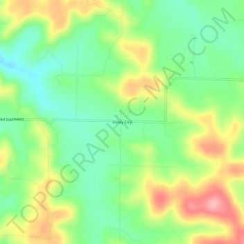
Name: Valley City topographic map, elevation, terrain.

Location: Valley City, Harrison County, Indiana, 47110, United States (38.07396 -86.24275 38.11396 -86.20275)

Average elevation: 653 ft

Minimum elevation: 482 ft

Maximum elevation: 896 ft

Harrison County trails, hiking, mountain biking, running and outdoor activities

Other topographic maps

Click on a map to view its topography, its elevation and its terrain.

Lanesville

United States > Indiana > Harrison County

Average elevation: 784 ft

New Amsterdam

United States > Indiana > Harrison County

Average elevation: 495 ft

New Middletown

United States > Indiana > Harrison County

Average elevation: 705 ft

Crandall

United States > Indiana > Harrison County

Average elevation: 712 ft

Laconia

United States > Indiana > Harrison County

Average elevation: 659 ft

Gear up for your next adventure:

🪶Fire Starter Kit - Reliable fire starter for survival and camping
🔥Camping Stove - Portable stove for camping and backcountry cooking
👖Convertible Hiking Pants - Versatile zip-off pants for changing altitudes and temperatures
🪶Paracord Bracelet - Survival bracelet with built‑in tools
🪓Survival Multi‑Tool - Versatile tool for camp and trail tasks

As an Amazon Associate, this site earns from qualifying purchases at no extra cost to you.