
Make a donation
Gear up for your next adventure:
As an Amazon Associate, this site earns from qualifying purchases at no extra cost to you.
Artá topographic map
Click on the map to display elevation.
Make a donation
Gear up for your next adventure:
As an Amazon Associate, this site earns from qualifying purchases at no extra cost to you.
About this map
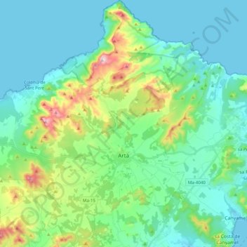
Name: Artá topographic map, elevation, terrain.
Location: Artá, Llevant, Islas Baleares, 07570, España (39.63939 3.22507 39.78939 3.42063)
Average elevation: 390 ft
Minimum elevation: 0 ft
Maximum elevation: 1,814 ft
Make a donation
Gear up for your next adventure:
As an Amazon Associate, this site earns from qualifying purchases at no extra cost to you.
Other topographic maps
Click on a map to view its topography, its elevation and its terrain.
Manacor
España > Islas Baleares > Llevant
En 2019 contaba con 43 808 habitantes. Su término municipal tiene una superficie de 260 km² y una densidad de 168,29 hab/km² y se encuentra situado a una altitud media de 80 m s. n. m. Por su población, Manacor es el tercer municipio de la isla y el segundo en cuanto a superficie.
Average elevation: 328 ft
Puig de Son Manxo
España > Islas Baleares > Llevant > San Lorenzo del Cardessar
Average elevation: 197 ft
Make a donation
Gear up for your next adventure:
As an Amazon Associate, this site earns from qualifying purchases at no extra cost to you.
puig de Calicant
España > Islas Baleares > Llevant > San Lorenzo del Cardessar
Average elevation: 833 ft
Make a donation
Gear up for your next adventure:
As an Amazon Associate, this site earns from qualifying purchases at no extra cost to you.
Parc Natural de la penísula de Llevant
España > Islas Baleares > Llevant > Artá
Average elevation: 558 ft
Castell de la Punta de n'Amer
España > Islas Baleares > Llevant > Son Moro
La torre es una estructura cúbica rodeada por un foso y construida con sillares de arenisca. Se encuentra situada a unos 35 metros de altitud y se construyó hacia finales del siglo XVII.
Average elevation: 13 ft
Make a donation
Gear up for your next adventure:
As an Amazon Associate, this site earns from qualifying purchases at no extra cost to you.
Make a donation
Gear up for your next adventure:
As an Amazon Associate, this site earns from qualifying purchases at no extra cost to you.