
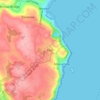
Paul topographic map
Interactive map
Click on the map to display elevation.
About this map
Name: Paul topographic map, elevation, terrain.
Location: Paul, Penzance, Cornwall, England, TR19 6UA, United Kingdom (50.06961 -5.56641 50.10961 -5.52641)
Average elevation: 161 ft
Minimum elevation: -3 ft
Maximum elevation: 384 ft
Other topographic maps
Click on a map to view its topography, its elevation and its terrain.
Gulval
United Kingdom > England > Cornwall > Penzance
Gulval, Penzance, Cornwall, England, TR18 3BB, United Kingdom
Average elevation: 174 ft