
Make a donation
Gear up for your next adventure:
As an Amazon Associate, this site earns from qualifying purchases at no extra cost to you.
Kudremukha topographic map
Click on the map to display elevation.
Make a donation
Gear up for your next adventure:
As an Amazon Associate, this site earns from qualifying purchases at no extra cost to you.
Kudremukha
The town of Kudremukha (KIOCL & etc.) lies at an elevation of around 815 metres (2,674 ft), whereas the peak stands at 1,894 metres (6,214 ft). The southern and western sides of the park form the steep slope of the Western Ghats ridgeline, with the altitude varying from 100 m - 1892 m (peak). The northern, central, and eastern portions of the park constitute a chain of rolling hills with a mosaic of natural grassland and shola forests. Kudremukha receives an average annual rainfall of 7000 mm, largely due to the forest types of mainly evergreen vegetation that can be found here.
Make a donation
Gear up for your next adventure:
As an Amazon Associate, this site earns from qualifying purchases at no extra cost to you.
About this map
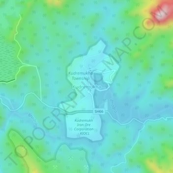
Name: Kudremukha topographic map, elevation, terrain.
Location: Kudremukha, Kalasa taluk, Chikkamagaluru, Karnataka, India (13.19907 75.23103 13.23907 75.27103)
Average elevation: 2,815 ft
Minimum elevation: 2,543 ft
Maximum elevation: 4,065 ft
Make a donation
Gear up for your next adventure:
As an Amazon Associate, this site earns from qualifying purchases at no extra cost to you.