Geolocate

Paternoster topographic map

Interactive map

Click on the map to display elevation.

About this map

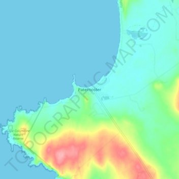
Name: Paternoster topographic map, elevation, terrain.

Location: Paternoster, Saldanha Bay Local Municipality, West Coast District Municipality, Western Cape, 7381, South Africa (-32.84904 17.85170 -32.76904 17.93170)

Average elevation: 66 ft

Minimum elevation: -3 ft

Maximum elevation: 322 ft

Other topographic maps

Click on a map to view its topography, its elevation and its terrain.

Saldanha Bay Ward 6

South Africa > Western Cape > West Coast District Municipality > Saldanha Bay Local Municipality

Saldanha Bay Ward 6, Saldanha Bay Local Municipality, West Coast District Municipality, Western Cape, South Africa

Average elevation: 174 ft

Tierkloof

South Africa > Western Cape > West Coast District Municipality > Saldanha Bay Local Municipality

Tierkloof, Saldanha Bay Local Municipality, West Coast District Municipality, Western Cape, 7380, South Africa

Average elevation: 302 ft