Geolocate

O'Donnell topographic map

Click on the map to display elevation.

About this map

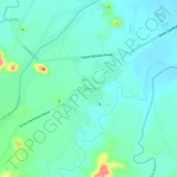
Name: O'Donnell topographic map, elevation, terrain.

Location: O'Donnell, Capas, Tarlac, Central Luzon, 2315, Philippines (15.33082 120.43775 15.37082 120.47775)

Average elevation: 420 ft

Minimum elevation: 351 ft

Maximum elevation: 709 ft

Other topographic maps

Click on a map to view its topography, its elevation and its terrain.

Tambo Lake

Philippines > Tarlac > Capas

Average elevation: 958 ft

Gear up for your next adventure:

📚Navigation Handbooks - Master the art of reading topographic maps and using a compass
🌧️Backpack Rain Cover - Keep gear dry in wet weather
🥇GPS Hiking Watch - Multi‑sport GPS watch with navigation and trail tracking
🧢Sun Protection Hats - Wide-brimmed and UPF-rated hats for high-altitude sun safety
📦Gear Storage Bags - Organize and protect outdoor equipment

As an Amazon Associate, this site earns from qualifying purchases at no extra cost to you.