
Make a donation
Gear up for your next adventure:
As an Amazon Associate, this site earns from qualifying purchases at no extra cost to you.
Montebelluna topographic map
Click on the map to display elevation.
Make a donation
Gear up for your next adventure:
As an Amazon Associate, this site earns from qualifying purchases at no extra cost to you.
Montebelluna
The territory of Montebelluna is largely flat, with altitudes ranging from 69 m a.s.l., found south of San Gaetano, to 144 m, north of Pederiva. The landscape is also characterized by the presence of two hills, including the western end of Montello (where the maximum altitude is, 343 m) and the more modest Capo di Monte (or Montebelluna Alta, or even the hill of Mercato Vecchio, 199 m). Between the two reliefs passes a natural corridor (along which the Feltrina passes), once the original bed of the Piave.
Make a donation
Gear up for your next adventure:
As an Amazon Associate, this site earns from qualifying purchases at no extra cost to you.
About this map
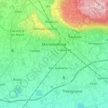
Name: Montebelluna topographic map, elevation, terrain.
Location: Montebelluna, Treviso, Veneto, 31044, Italy (45.72298 11.99231 45.81314 12.09770)
Average elevation: 407 ft
Minimum elevation: 131 ft
Maximum elevation: 1,211 ft
Make a donation
Gear up for your next adventure:
As an Amazon Associate, this site earns from qualifying purchases at no extra cost to you.
Other topographic maps
Click on a map to view its topography, its elevation and its terrain.