Geolocate

Excursion Inlet topographic map

Click on the map to display elevation.

About this map

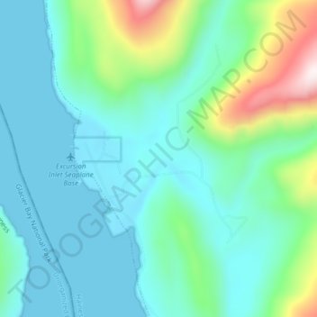
Name: Excursion Inlet topographic map, elevation, terrain.

Location: Excursion Inlet, Haines, Alaska, United States (58.39889 -135.44667 58.43889 -135.40667)

Average elevation: 486 ft

Minimum elevation: -20 ft

Maximum elevation: 2,444 ft

Haines trails, hiking, mountain biking, running and outdoor activities

Other topographic maps

Click on a map to view its topography, its elevation and its terrain.

Lutak

United States > Alaska > Haines

Average elevation: 2,146 ft

Gear up for your next adventure:

🔭Compact Binoculars - HD vision for scouting terrain and identifying distant landmarks
⛑️Personal Locator Beacon - Safety beacon for emergencies
🧭Hiking Compass - Precision compass for reliable navigation in the wilderness
🎒Waterproof Dry Bags - Keep your electronics and maps dry inside your pack
🌲Outdoor Survival Books - Best books on survival skills

As an Amazon Associate, this site earns from qualifying purchases at no extra cost to you.