
Fort Hunter topographic map
Click on the map to display elevation.
About this map
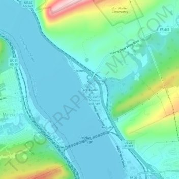
Name: Fort Hunter topographic map, elevation, terrain.
Average elevation: 489 ft
Minimum elevation: 299 ft
Maximum elevation: 1,250 ft
Dauphin County trails, hiking, mountain biking, running and outdoor activities
Other topographic maps
Click on a map to view its topography, its elevation and its terrain.
Susquehanna River
United States > Pennsylvania > Dauphin County > Middle Paxton Township
Average elevation: 387 ft
Blue Mountain
United States > Pennsylvania > Dauphin County > Middle Paxton Township
The ridge of Blue Mountain runs for 150 miles (240 km) through Pennsylvania, reaching an elevation of 2,270 feet (690 m) above sea level just north of the Pennsylvania Turnpike, near the borough of Newburg. Most of the ridgecrest, however, only reaches between 1,400 and 1,700 feet (430 and 520 m) in elevation.…
Average elevation: 653 ft
Clark Creek
United States > Pennsylvania > Dauphin County > Middle Paxton Township
Average elevation: 443 ft