Wathena topographic map
Interactive map
Click on the map to display elevation.
About this map
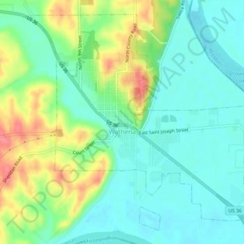
Name: Wathena topographic map, elevation, terrain.
Location: Wathena, Doniphan County, Kansas, 66090, United States (39.74689 -94.96457 39.77546 -94.92261)
Average elevation: 873 ft
Minimum elevation: 794 ft
Maximum elevation: 1,030 ft
Other topographic maps
Click on a map to view its topography, its elevation and its terrain.
Bendena
United States > Kansas > Doniphan County
Bendena, Doniphan County, Kansas, 66008, United States
Average elevation: 1,076 ft
Elwood
United States > Kansas > Doniphan County
Elwood, Doniphan County, Kansas, 66024, United States
Average elevation: 843 ft
Leona
United States > Kansas > Doniphan County
Leona, Doniphan County, Kansas, United States
Average elevation: 961 ft
Severance
United States > Kansas > Doniphan County
Severance, Doniphan County, Kansas, United States
Average elevation: 955 ft
Denton
United States > Kansas > Doniphan County
Denton, Doniphan County, Kansas, United States
Average elevation: 1,047 ft
Troy
United States > Kansas > Doniphan County
Troy, Doniphan County, Kansas, United States
Average elevation: 1,086 ft
White Cloud
United States > Kansas > Doniphan County
White Cloud, Doniphan County, Kansas, United States
Average elevation: 935 ft
Highland
United States > Kansas > Doniphan County
Highland, Doniphan County, Kansas, 66035, United States
Average elevation: 1,033 ft
Fanning
United States > Kansas > Doniphan County
Fanning, Doniphan County, Kansas, United States
Average elevation: 955 ft