Geolocate

Achra topographic map

Click on the map to display elevation.

About this map

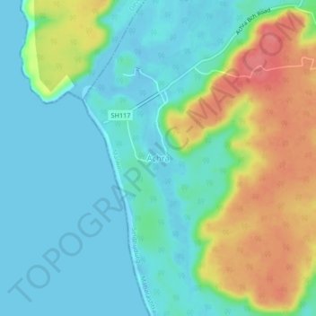
Name: Achra topographic map, elevation, terrain.

Location: Achra, Malvan Taluka, Sindhudurg, Maharashtra, 416614, India (16.17248 73.42498 16.21248 73.46498)

Average elevation: 72 ft

Minimum elevation: -10 ft

Maximum elevation: 230 ft

Other topographic maps

Click on a map to view its topography, its elevation and its terrain.

Dikwal

India > Maharashtra > Malvan Taluka

Average elevation: 338 ft

Tarkarli beach

India > Maharashtra > Malvan Taluka > Tarkarli

Average elevation: 36 ft

Gear up for your next adventure:

📶Satellite Messenger - Communication device off‑grid
💧Water Purification System - Clean water on the trail with reliable purifiers
🧼Biodegradable Camping Soap - Eco‑friendly soap for outdoor hygiene
🧢Outdoor Hiking Hat - Sun protection hat for outdoor explorers
👓Polarized Sunglasses - Outdoor sunglasses for glare reduction

As an Amazon Associate, this site earns from qualifying purchases at no extra cost to you.