Geolocate

Seymour topographic map

Click on the map to display elevation.

About this map

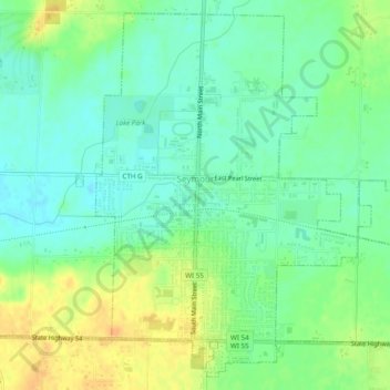
Name: Seymour topographic map, elevation, terrain.

Location: Seymour, Outagamie County, Wisconsin, 54165, United States (44.49738 -88.34527 44.52968 -88.29673)

Average elevation: 810 ft

Minimum elevation: 768 ft

Maximum elevation: 869 ft

Outagamie County trails, hiking, mountain biking, running and outdoor activities

Other topographic maps

Click on a map to view its topography, its elevation and its terrain.

Freedom

United States > Wisconsin > Outagamie County

Average elevation: 741 ft

Leeman

United States > Wisconsin > Outagamie County

Average elevation: 791 ft

Gear up for your next adventure:

Solar GPS Watches - Advanced multisport watches with built-in topographic maps
🗃️Trail First Aid Kit - Essential kit for outdoor injuries and emergencies
🎁Geography Themed Gifts - Unique gift ideas for map lovers and geography enthusiasts
👖Convertible Hiking Pants - Versatile zip-off pants for changing altitudes and temperatures
🔊Portable Camp Speaker - Music and alerts at camp

As an Amazon Associate, this site earns from qualifying purchases at no extra cost to you.