
Make a donation
Gear up for your next adventure:
As an Amazon Associate, this site earns from qualifying purchases at no extra cost to you.
West Point topographic map
Click on the map to display elevation.
Make a donation
Gear up for your next adventure:
As an Amazon Associate, this site earns from qualifying purchases at no extra cost to you.
About this map
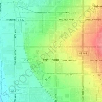
Name: West Point topographic map, elevation, terrain.
Location: West Point, Davis County, Utah, United States (41.09641 -112.12711 41.14967 -112.05487)
Average elevation: 4,295 ft
Minimum elevation: 4,206 ft
Maximum elevation: 4,439 ft
Davis County trails, hiking, mountain biking, running and outdoor activities
Make a donation
Gear up for your next adventure:
As an Amazon Associate, this site earns from qualifying purchases at no extra cost to you.
Other topographic maps
Click on a map to view its topography, its elevation and its terrain.
Make a donation
Gear up for your next adventure:
As an Amazon Associate, this site earns from qualifying purchases at no extra cost to you.
North Salt Lake
United States > Utah > Davis County > North Salt Lake > North Salt Lake
Average elevation: 4,665 ft
The Great Salt Lake Shorelands Preserve
United States > Utah > Davis County
Average elevation: 4,239 ft
Make a donation
Gear up for your next adventure:
As an Amazon Associate, this site earns from qualifying purchases at no extra cost to you.