
Make a donation
Gear up for your next adventure:
As an Amazon Associate, this site earns from qualifying purchases at no extra cost to you.
Pfaffengrün topographic map
Click on the map to display elevation.
Make a donation
Gear up for your next adventure:
As an Amazon Associate, this site earns from qualifying purchases at no extra cost to you.
Pfaffengrün
Der Ort wird von der TaktBus-Linie 83 des Verkehrsverbunds Vogtland bedient. Diese verbindet Pfaffengrün im Zweistundentakt mit Treuen, Netzschkau und Reichenbach. Das Gewerbegebiet Goldene Höhe wird von der TaktBus-Linie 63 (Plauen – Lengenfeld) angefahren.
Make a donation
Gear up for your next adventure:
As an Amazon Associate, this site earns from qualifying purchases at no extra cost to you.
About this map
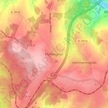
Name: Pfaffengrün topographic map, elevation, terrain.
Average elevation: 1,476 ft
Minimum elevation: 1,102 ft
Maximum elevation: 1,640 ft
Make a donation
Gear up for your next adventure:
As an Amazon Associate, this site earns from qualifying purchases at no extra cost to you.