
Thank you for supporting this site ❤️
Make a donation
Make a donation
Gear up for your next adventure:
As an Amazon Associate, this site earns from qualifying purchases at no extra cost to you.
Datag topographic map
Click on the map to display elevation.
Thank you for supporting this site ❤️
Make a donation
Make a donation
Gear up for your next adventure:
As an Amazon Associate, this site earns from qualifying purchases at no extra cost to you.
About this map
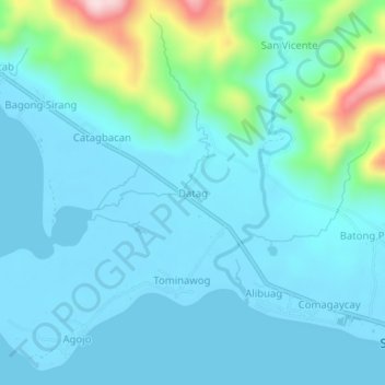
Name: Datag topographic map, elevation, terrain.
Location: Datag, San Andres, Catanduanes, Bicol Region, Philippines (13.59450 124.05354 13.63450 124.09354)
Average elevation: 174 ft
Minimum elevation: -3 ft
Maximum elevation: 1,119 ft
Thank you for supporting this site ❤️
Make a donation
Make a donation
Gear up for your next adventure:
As an Amazon Associate, this site earns from qualifying purchases at no extra cost to you.