
Make a donation
Gear up for your next adventure:
As an Amazon Associate, this site earns from qualifying purchases at no extra cost to you.
Gallarate topographic map
Click on the map to display elevation.
Make a donation
Gear up for your next adventure:
As an Amazon Associate, this site earns from qualifying purchases at no extra cost to you.
Gallarate
Founded by the Gauls and later conquered by the Romans, Gallarate was mentioned as an important vicus or village in documents dating back to the Roman conquest of what was then called Gallia Cisalpina. After the Carolingian conquest of northern-central Italy, a castle was erected upon the remains of the original Roman fortifications located beside the still-existing Basilica of Santa Maria. The castle has disappeared, but its ancient location is identified through the city's topography and by the street name Via Postcastello.
Make a donation
Gear up for your next adventure:
As an Amazon Associate, this site earns from qualifying purchases at no extra cost to you.
About this map
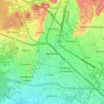
Name: Gallarate topographic map, elevation, terrain.
Location: Gallarate, Varese, Lombardy, 21013, Italy (45.63119 8.75368 45.69043 8.83244)
Average elevation: 833 ft
Minimum elevation: 728 ft
Maximum elevation: 1,014 ft
Make a donation
Gear up for your next adventure:
As an Amazon Associate, this site earns from qualifying purchases at no extra cost to you.
Other topographic maps
Click on a map to view its topography, its elevation and its terrain.
Parco archeologico di Castel Seprio
Italy > Lombardy > Varese > Castelseprio > Vico Seprio
Average elevation: 1,030 ft
Make a donation
Gear up for your next adventure:
As an Amazon Associate, this site earns from qualifying purchases at no extra cost to you.