Geolocate

Bass topographic map

Click on the map to display elevation.

About this map

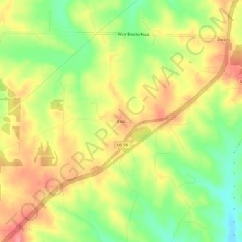
Name: Bass topographic map, elevation, terrain.

Location: Bass, Cole County, Missouri, United States (38.41198 -92.34518 38.45198 -92.30518)

Average elevation: 764 ft

Minimum elevation: 614 ft

Maximum elevation: 892 ft

Cole County trails, hiking, mountain biking, running and outdoor activities

Other topographic maps

Click on a map to view its topography, its elevation and its terrain.

Taos

United States > Missouri > Cole County

Average elevation: 715 ft

Lohman

United States > Missouri > Cole County

Average elevation: 715 ft

Centertown

United States > Missouri > Cole County

Average elevation: 801 ft

Wardsville

United States > Missouri > Cole County

Average elevation: 669 ft

Gear up for your next adventure:

🔋Rechargeable Batteries - Power up your outdoor devices
🌡️Handheld Weather Meters - Measure wind, temp, and pressure for safe mountain travel
🔥Plasma Lighters - Windproof lighters that work in any weather condition
🪶Camping Sleeping Pad - Comfortable sleeping pad for backpacking
🛶Inflatable Kayak - Portable kayak for rivers, lakes, and expeditions

As an Amazon Associate, this site earns from qualifying purchases at no extra cost to you.