Geolocate

Amboy topographic map

Click on the map to display elevation.

About this map

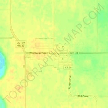
Name: Amboy topographic map, elevation, terrain.

Location: Amboy, Blue Earth County, Minnesota, United States (43.88375 -94.16858 43.89154 -94.14852)

Average elevation: 1,043 ft

Minimum elevation: 984 ft

Maximum elevation: 1,063 ft

Blue Earth County trails, hiking, mountain biking, running and outdoor activities

Other topographic maps

Click on a map to view its topography, its elevation and its terrain.

Garden City

United States > Minnesota > Blue Earth County

Average elevation: 974 ft

Benning

United States > Minnesota > Blue Earth County > Mankato

Average elevation: 843 ft

Beauford

United States > Minnesota > Blue Earth County

Average elevation: 1,004 ft

Gear up for your next adventure:

🪑Portable Camp Table - Compact table for campsite meals
🚁Photography Drones - Capture stunning aerial views of landforms and topography
🧯Emergency Survival Kit - All‑in‑one survival essentials for the backcountry
🧷Carabiner Set - Durable clips for gear attachment
Backpacking Tent - Lightweight and durable tent for multi‑day hikes

As an Amazon Associate, this site earns from qualifying purchases at no extra cost to you.