
Make a donation
Gear up for your next adventure:
As an Amazon Associate, this site earns from qualifying purchases at no extra cost to you.
Parkman Township topographic map
Click on the map to display elevation.
Make a donation
Gear up for your next adventure:
As an Amazon Associate, this site earns from qualifying purchases at no extra cost to you.
About this map
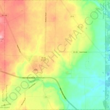
Name: Parkman Township topographic map, elevation, terrain.
Location: Parkman Township, Geauga County, Ohio, 44491, United States (41.34744 -81.09945 41.42602 -81.00315)
Average elevation: 1,099 ft
Minimum elevation: 846 ft
Maximum elevation: 1,391 ft
Geauga County trails, hiking, mountain biking, running and outdoor activities
Make a donation
Gear up for your next adventure:
As an Amazon Associate, this site earns from qualifying purchases at no extra cost to you.
Other topographic maps
Click on a map to view its topography, its elevation and its terrain.
Make a donation
Gear up for your next adventure:
As an Amazon Associate, this site earns from qualifying purchases at no extra cost to you.