
Make a donation
Gear up for your next adventure:
As an Amazon Associate, this site earns from qualifying purchases at no extra cost to you.
Masontown topographic map
Click on the map to display elevation.
Make a donation
Gear up for your next adventure:
As an Amazon Associate, this site earns from qualifying purchases at no extra cost to you.
About this map
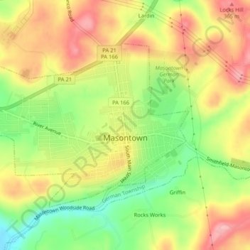
Name: Masontown topographic map, elevation, terrain.
Average elevation: 1,010 ft
Minimum elevation: 774 ft
Maximum elevation: 1,220 ft
Fayette County trails, hiking, mountain biking, running and outdoor activities
Make a donation
Gear up for your next adventure:
As an Amazon Associate, this site earns from qualifying purchases at no extra cost to you.
Other topographic maps
Click on a map to view its topography, its elevation and its terrain.
South Uniontown
United States > Pennsylvania > Fayette County > South Union Township
Average elevation: 1,106 ft
New Meadow Run Bruderhof
United States > Pennsylvania > Fayette County > Wharton Township
Average elevation: 1,913 ft
Morgan Run
United States > Pennsylvania > Fayette County > Dunbar Township
Average elevation: 1,506 ft
West Leisenring
United States > Pennsylvania > Fayette County > Dunbar Township
Average elevation: 1,099 ft
Make a donation
Gear up for your next adventure:
As an Amazon Associate, this site earns from qualifying purchases at no extra cost to you.
Uledi
United States > Pennsylvania > Fayette County > South Union Township
Average elevation: 1,188 ft
Mount Braddock
United States > Pennsylvania > Fayette County > North Union Township
Average elevation: 1,302 ft
Merrittstown
United States > Pennsylvania > Fayette County > Redstone Township
Average elevation: 1,043 ft
Melcroft
United States > Pennsylvania > Fayette County > Saltlick Township
Average elevation: 1,670 ft
Make a donation
Gear up for your next adventure:
As an Amazon Associate, this site earns from qualifying purchases at no extra cost to you.
McClellandtown
United States > Pennsylvania > Fayette County > German Township
Average elevation: 1,109 ft
Leisenring
United States > Pennsylvania > Fayette County > Dunbar Township
Average elevation: 1,129 ft
Lake Lynn
United States > Pennsylvania > Fayette County > Springhill Township
Average elevation: 1,063 ft
Make a donation
Gear up for your next adventure:
As an Amazon Associate, this site earns from qualifying purchases at no extra cost to you.
La Belle
United States > Pennsylvania > Fayette County > Luzerne Township > Luzerne
Average elevation: 971 ft
Keisterville
United States > Pennsylvania > Fayette County > Menallen Township
Average elevation: 1,138 ft
Indian Head
United States > Pennsylvania > Fayette County > Saltlick Township
Average elevation: 1,680 ft
Make a donation
Gear up for your next adventure:
As an Amazon Associate, this site earns from qualifying purchases at no extra cost to you.
Fairbank
United States > Pennsylvania > Fayette County > Redstone Township
Average elevation: 1,086 ft
East Millsboro
United States > Pennsylvania > Fayette County > Luzerne Township
Average elevation: 1,017 ft
Make a donation
Gear up for your next adventure:
As an Amazon Associate, this site earns from qualifying purchases at no extra cost to you.
Star Junction
United States > Pennsylvania > Fayette County > Perry Township
Average elevation: 1,175 ft
Lemont Furnace
United States > Pennsylvania > Fayette County > North Union Township
Average elevation: 1,220 ft
Make a donation
Gear up for your next adventure:
As an Amazon Associate, this site earns from qualifying purchases at no extra cost to you.
New Salem
United States > Pennsylvania > Fayette County > Menallen Township
Average elevation: 1,086 ft
Grindstone
United States > Pennsylvania > Fayette County > Jefferson Township
Average elevation: 1,027 ft
Champion
United States > Pennsylvania > Fayette County > Saltlick Township
Average elevation: 1,657 ft
Make a donation
Gear up for your next adventure:
As an Amazon Associate, this site earns from qualifying purchases at no extra cost to you.
Trotter
United States > Pennsylvania > Fayette County > Dunbar Township > Trotter
Average elevation: 1,056 ft
Tower Hill Number Two
United States > Pennsylvania > Fayette County > Luzerne Township > Tower Hill Number Two
Average elevation: 1,066 ft
Jumonville
United States > Pennsylvania > Fayette County > North Union Township > Jumonville
Average elevation: 2,011 ft
Millertown
United States > Pennsylvania > Fayette County > Saltlick Township
Average elevation: 1,795 ft
Make a donation
Gear up for your next adventure:
As an Amazon Associate, this site earns from qualifying purchases at no extra cost to you.
Mill Run
United States > Pennsylvania > Fayette County > Springfield Township
Average elevation: 1,581 ft
Buena Vista
United States > Pennsylvania > Fayette County > Franklin Township
Average elevation: 1,260 ft
Make a donation
Gear up for your next adventure:
As an Amazon Associate, this site earns from qualifying purchases at no extra cost to you.