
Make a donation
Gear up for your next adventure:
As an Amazon Associate, this site earns from qualifying purchases at no extra cost to you.
Kanorado topographic map
Click on the map to display elevation.
Make a donation
Gear up for your next adventure:
As an Amazon Associate, this site earns from qualifying purchases at no extra cost to you.
Kanorado
On February 10, 2016 the House of Representatives of the State of Kansas passed a Resolution (Res.#6033) designating the City of Kanorado as the Top City of Kansas. This is due to it being the highest city elevation in the State of Kansas at 3,907 feet.
Make a donation
Gear up for your next adventure:
As an Amazon Associate, this site earns from qualifying purchases at no extra cost to you.
About this map
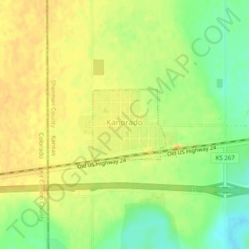
Name: Kanorado topographic map, elevation, terrain.
Location: Kanorado, Sherman County, Kansas, United States (39.33279 -102.04204 39.34040 -102.03179)
Average elevation: 3,907 ft
Minimum elevation: 3,848 ft
Maximum elevation: 3,937 ft
Sherman County trails, hiking, mountain biking, running and outdoor activities
Make a donation
Gear up for your next adventure:
As an Amazon Associate, this site earns from qualifying purchases at no extra cost to you.