
Make a donation
Gear up for your next adventure:
As an Amazon Associate, this site earns from qualifying purchases at no extra cost to you.
Sharurah topographic map
Click on the map to display elevation.
Make a donation
Gear up for your next adventure:
As an Amazon Associate, this site earns from qualifying purchases at no extra cost to you.
About this map
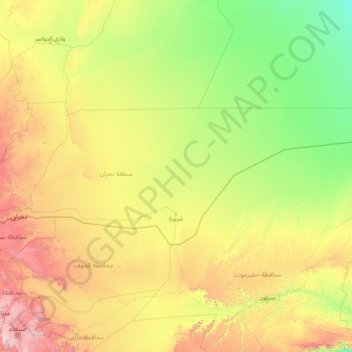
Name: Sharurah topographic map, elevation, terrain.
Location: Sharurah, Najran Region, Saudi Arabia (16.95000 45.54139 19.33330 52.00175)
Average elevation: 2,657 ft
Minimum elevation: 696 ft
Maximum elevation: 11,634 ft
Make a donation
Gear up for your next adventure:
As an Amazon Associate, this site earns from qualifying purchases at no extra cost to you.
Other topographic maps
Click on a map to view its topography, its elevation and its terrain.
Najran
Najran has a hot desert climate (Köppen BWh), typical of the Arabian Peninsula. Rainfall is very sporadic, and consists of light individual rainfall. Despite its location in far southern Saudi Arabia, Najran's average temperature is approximately 3.3 °C or 5.9 °F cooler than that of the Saudi capital…
Average elevation: 4,797 ft
Make a donation
Gear up for your next adventure:
As an Amazon Associate, this site earns from qualifying purchases at no extra cost to you.
Najran
Najran has a hot desert climate (Köppen BWh), typical of the Arabian Peninsula. Rainfall is very sporadic, and consists of light individual rainfall. Despite its location in far southern Saudi Arabia, Najran's average temperature is approximately 3.3 °C or 5.9 °F cooler than that of the Saudi capital…
Average elevation: 4,797 ft