
Make a donation
Gear up for your next adventure:
As an Amazon Associate, this site earns from qualifying purchases at no extra cost to you.
Cotton Flat topographic map
Click on the map to display elevation.
Make a donation
Gear up for your next adventure:
As an Amazon Associate, this site earns from qualifying purchases at no extra cost to you.
About this map
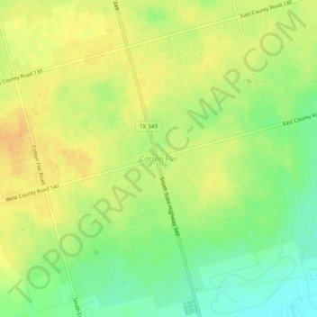
Name: Cotton Flat topographic map, elevation, terrain.
Location: Cotton Flat, Midland County, Texas, 79706, United States (31.90901 -102.07986 31.94901 -102.03986)
Average elevation: 2,776 ft
Minimum elevation: 2,713 ft
Maximum elevation: 2,815 ft
Midland County trails, hiking, mountain biking, running and outdoor activities
Make a donation
Gear up for your next adventure:
As an Amazon Associate, this site earns from qualifying purchases at no extra cost to you.
Other topographic maps
Click on a map to view its topography, its elevation and its terrain.
Chris Davidson Opportunity Park
United States > Texas > Midland County > Midland
Average elevation: 2,854 ft