
Thank you for supporting this site ❤️
Make a donation
Make a donation
Gear up for your next adventure:
As an Amazon Associate, this site earns from qualifying purchases at no extra cost to you.
Oberzell topographic map
Click on the map to display elevation.
Thank you for supporting this site ❤️
Make a donation
Make a donation
Gear up for your next adventure:
As an Amazon Associate, this site earns from qualifying purchases at no extra cost to you.
About this map
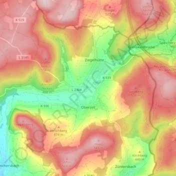
Name: Oberzell topographic map, elevation, terrain.
Location: Oberzell, Sinntal, Main-Kinzig-Kreis, Hesse, Germany (50.30977 9.67089 50.36887 9.74745)
Average elevation: 1,486 ft
Minimum elevation: 889 ft
Maximum elevation: 1,949 ft
Thank you for supporting this site ❤️
Make a donation
Make a donation
Gear up for your next adventure:
As an Amazon Associate, this site earns from qualifying purchases at no extra cost to you.