Geolocate

Lake View topographic map

Click on the map to display elevation.

About this map

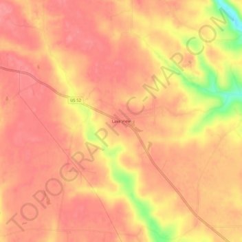
Name: Lake View topographic map, elevation, terrain.

Location: Lake View, Franklin County, Indiana, United States (39.46560 -85.26830 39.50560 -85.22830)

Average elevation: 988 ft

Minimum elevation: 781 ft

Maximum elevation: 1,050 ft

Franklin County trails, hiking, mountain biking, running and outdoor activities

Other topographic maps

Click on a map to view its topography, its elevation and its terrain.

Oldenburg

United States > Indiana > Franklin County

Average elevation: 945 ft

Mount Carmel

United States > Indiana > Franklin County

Average elevation: 1,007 ft

Gear up for your next adventure:

📻Weather Alert Radios - Stay informed of storm risks while off-the-grid
🔭Telescopic Hiking Pole - Adjustable pole for hiking stability
🪶Paracord Bracelet - Survival bracelet with built‑in tools
🩳Quick‑Dry Hiking Shorts - Comfortable and quick‑dry shorts for summer hiking
👖Convertible Hiking Pants - Versatile zip-off pants for changing altitudes and temperatures

As an Amazon Associate, this site earns from qualifying purchases at no extra cost to you.