
Make a donation
Gear up for your next adventure:
As an Amazon Associate, this site earns from qualifying purchases at no extra cost to you.
Minicoy topographic map
Click on the map to display elevation.
Make a donation
Gear up for your next adventure:
As an Amazon Associate, this site earns from qualifying purchases at no extra cost to you.
About this map
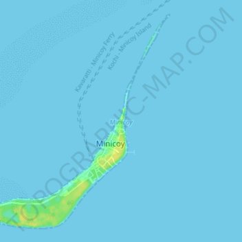
Name: Minicoy topographic map, elevation, terrain.
Location: Minicoy, Lakshadweep, 682559, India (8.26566 73.01070 8.32507 73.07848)
Average elevation: 3 ft
Minimum elevation: -3 ft
Maximum elevation: 56 ft
Make a donation
Gear up for your next adventure:
As an Amazon Associate, this site earns from qualifying purchases at no extra cost to you.
Other topographic maps
Click on a map to view its topography, its elevation and its terrain.
Kavaratti
India > Lakshadweep > Kavaratti
The island of Kavaratti lies 360 km (190 nmi) off the coast of the state of Kerala at 10°34′N 72°38′E / 10.57°N 72.64°E / 10.57; 72.64. It has an average elevation of 0 metres (0 feet).
Average elevation: 0 ft
Kavaratti Island
India > Lakshadweep > Kavaratti > Kavaratti
The island of Kavaratti lies 360 km (190 nmi) off the coast of the state of Kerala at 10°34′N 72°38′E / 10.57°N 72.64°E / 10.57; 72.64. It has an average elevation of 0 metres (0 feet).
Average elevation: 7 ft
Kavaratti
India > Lakshadweep > Kavaratti
The atoll of Kavaratti lies 360 km (220 mi) off the Malabar coast of mainland India. The island is 5.6 km (3.5 mi) long, and 1.6 km (0.99 mi) wide, and occupies an area of 4.22 km2 (1.63 sq mi). It is surrounded by a 6 km (3.7 mi) long lagoon with an area of 4.96 km2 (1.92 sq mi). It is located to the east of…
Average elevation: 0 ft
Make a donation
Gear up for your next adventure:
As an Amazon Associate, this site earns from qualifying purchases at no extra cost to you.