Geolocate

Letts topographic map

Click on the map to display elevation.

About this map

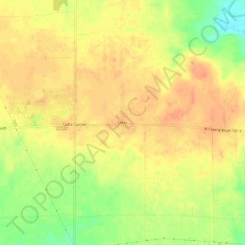
Name: Letts topographic map, elevation, terrain.

Location: Letts, Decatur County, Indiana, United States (39.21505 -85.58497 39.25505 -85.54497)

Average elevation: 873 ft

Minimum elevation: 781 ft

Maximum elevation: 915 ft

Decatur County trails, hiking, mountain biking, running and outdoor activities

Other topographic maps

Click on a map to view its topography, its elevation and its terrain.

Lake Santee

United States > Indiana > Decatur County

Average elevation: 1,007 ft

St. Paul

United States > Indiana > Decatur County

Average elevation: 846 ft

Westport

United States > Indiana > Decatur County

Average elevation: 817 ft

Millhousen

United States > Indiana > Decatur County

Average elevation: 909 ft

New Point

United States > Indiana > Decatur County

Average elevation: 988 ft

Gear up for your next adventure:

🔪Outdoor Multitools - Essential survival tools for gear repair and field use
🧭Map Reading Tools - Tools and kits for map navigation
🔋Solar Power Banks - Keep your GPS and phone charged in remote wilderness areas
🎒Gear Packing Cubes - Organize your backpack efficiently
🎒Trekking Poles - Sturdy poles for balance and stability on rough terrain

As an Amazon Associate, this site earns from qualifying purchases at no extra cost to you.