
Serdj El Ghoul topographic map
Interactive map
Click on the map to display elevation.
About this map
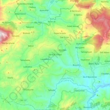
Name: Serdj El Ghoul topographic map, elevation, terrain.
Location: Serdj El Ghoul, Daïra Babor, Sétif, Algérie (36.39863 5.50953 36.55470 5.66762)
Average elevation: 3,028 ft
Minimum elevation: 1,726 ft
Maximum elevation: 6,211 ft
Other topographic maps
Click on a map to view its topography, its elevation and its terrain.
Ighil Oughlad
Algérie > Sétif > Daïra Babor > Larbaâ
Ighil Oughlad, Larbaâ, Babor, Daïra Babor, Sétif, Algérie
Average elevation: 3,238 ft
Douar Bousnina
Algérie > Sétif > Daïra Babor > Boussaldoue (Cheurfa)
Douar Bousnina, Boussaldoue (Cheurfa), Babor, Daïra Babor, Sétif, Algérie
Average elevation: 2,864 ft
Djebel Brâkou
Algérie > Sétif > Daïra Babor > Babor
Djebel Brâkou, Babor, Daïra Babor, Sétif, Algérie
Average elevation: 3,232 ft
Ouled Yahia
Algérie > Sétif > Daïra Babor
Ouled Yahia, Babor, Daïra Babor, Sétif, Algérie
Average elevation: 2,523 ft