
Greenwood Park topographic map
Interactive map
Click on the map to display elevation.
About this map
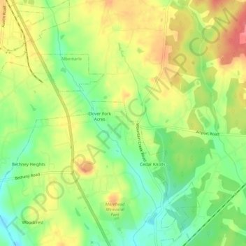
Name: Greenwood Park topographic map, elevation, terrain.
Average elevation: 584 ft
Minimum elevation: 472 ft
Maximum elevation: 699 ft
Other topographic maps
Click on a map to view its topography, its elevation and its terrain.
Morrow Mountain State Park
United States > North Carolina > Stanly County > Albemarle
Morrow Mountain State Park, 49104, Albemarle, Stanly County, North Carolina, 28001, United States
Average elevation: 495 ft