Geolocate

Allsboro topographic map

Click on the map to display elevation.

About this map

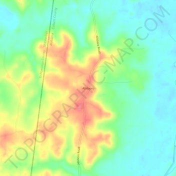
Name: Allsboro topographic map, elevation, terrain.

Location: Allsboro, Colbert County, Alabama, United States (34.67426 -88.13032 34.71426 -88.09032)

Average elevation: 512 ft

Minimum elevation: 413 ft

Maximum elevation: 666 ft

Colbert County trails, hiking, mountain biking, running and outdoor activities

Other topographic maps

Click on a map to view its topography, its elevation and its terrain.

Cherokee

United States > Alabama > Colbert County

Average elevation: 541 ft

Littleville

United States > Alabama > Colbert County

Average elevation: 689 ft

Sheffield

United States > Alabama > Colbert County

Average elevation: 495 ft

Gear up for your next adventure:

🛶Inflatable Kayak - Portable kayak for rivers, lakes, and expeditions
🌡️Handheld Weather Meters - Measure wind, temp, and pressure for safe mountain travel
👖Convertible Hiking Pants - Versatile zip-off pants for changing altitudes and temperatures
❄️Traction Cleats - Prevent slips on icy trails during winter hikes
🛡️Insect Repellent - Protection against bugs during outdoor activities

As an Amazon Associate, this site earns from qualifying purchases at no extra cost to you.