
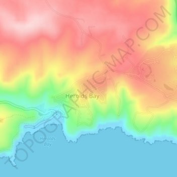
Herolds Bay topographic map
Interactive map
Click on the map to display elevation.
About this map
Name: Herolds Bay topographic map, elevation, terrain.
Average elevation: 344 ft
Minimum elevation: -3 ft
Maximum elevation: 712 ft
Other topographic maps
Click on a map to view its topography, its elevation and its terrain.
Groot-Brakrivier
South Africa > Western Cape > George
Groot-Brakrivier, Mossel Bay Local Municipality, George, Western Cape, South Africa
Average elevation: 312 ft
Map of Africa
South Africa > Western Cape > George
Map of Africa, Remskoen, George Ward 4, George Local Municipality, George, Western Cape, 6560, South Africa
Average elevation: 262 ft
Kurland
South Africa > Western Cape > George
Kurland, George, Western Cape, 6602, South Africa
Average elevation: 741 ft
Geelhoutboom
South Africa > Western Cape > George
Geelhoutboom, George Ward 22, George Local Municipality, George, Western Cape, South Africa
Average elevation: 820 ft
Reebok
South Africa > Western Cape > George
Reebok, George, Western Cape, 6503, South Africa
Average elevation: 98 ft
Stilbaai
South Africa > Western Cape > George
Stilbaai, George, Western Cape, South Africa
Average elevation: 187 ft
Oudtshoorn
South Africa > Western Cape > George
Oudtshoorn, Oudtshoorn Local Municipality, George, Western Cape, South Africa
Average elevation: 1,161 ft
Oudtshoorn Local Municipality
South Africa > Western Cape > George
Oudtshoorn Local Municipality, George, Western Cape, South Africa
Average elevation: 2,087 ft
Heidelberg
South Africa > Western Cape > George
Heidelberg, George, Western Cape, South Africa
Average elevation: 479 ft
Witsand
South Africa > Western Cape > George
Witsand, George, Western Cape, 6666, South Africa
Average elevation: 128 ft