Geolocate

Stilbaai topographic map

Click on the map to display elevation.

About this map

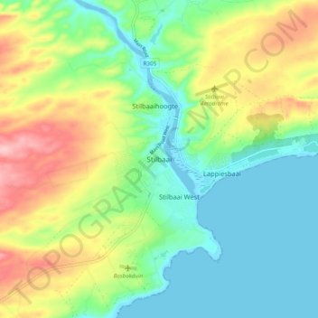
Name: Stilbaai topographic map, elevation, terrain.

Location: Stilbaai, George, Western Cape, South Africa (-34.40833 21.37111 -34.32833 21.45111)

Average elevation: 187 ft

Minimum elevation: -10 ft

Maximum elevation: 525 ft

Other topographic maps

Click on a map to view its topography, its elevation and its terrain.

Touwsranten

South Africa > Western Cape > George

Average elevation: 663 ft

Danabaai

South Africa > Western Cape > George

Average elevation: 358 ft

Oudtshoorn

South Africa > Western Cape > George

Average elevation: 1,158 ft

Oudtshoorn

South Africa > Western Cape > George

Average elevation: 1,158 ft

Friemersheim

South Africa > Western Cape > George

Average elevation: 860 ft

Oudtshoorn

South Africa > Western Cape > George

Average elevation: 1,158 ft

Garden Route Dam

South Africa > Western Cape > George

Average elevation: 656 ft

Gear up for your next adventure:

🧭Map Reading Tools - Tools and kits for map navigation
🥘Titanium Cookware - Durable, featherlight pots and pans for backpacking
🌧️Backpack Rain Cover - Keep gear dry in wet weather
GPS Sports Watch - GPS watch for running, hiking and training
🪶Compact Camp Shovel - Folding shovel for campsite tasks

As an Amazon Associate, this site earns from qualifying purchases at no extra cost to you.