Geolocate

Devils Tower topographic map

Click on the map to display elevation.

About this map
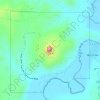
Name: Devils Tower topographic map, elevation, terrain.

Location: Devils Tower, Crook County, Wyoming, United States (44.58928 -104.71676 44.59192 -104.71367)

Average elevation: 4,055 ft

Minimum elevation: 3,839 ft

Maximum elevation: 5,075 ft

Crook County trails, hiking, mountain biking, running and outdoor activities

Other topographic maps

Click on a map to view its topography, its elevation and its terrain.

Sundance

United States > Wyoming > Crook County

Average elevation: 4,944 ft

Beulah

United States > Wyoming > Crook County > Beulah

Average elevation: 3,547 ft

Pine Haven

United States > Wyoming > Crook County

Average elevation: 4,183 ft

Bear's Lodge

United States > Wyoming > Crook County

Average elevation: 4,058 ft

Bear's Lodge

United States > Wyoming > Crook County

Average elevation: 4,058 ft

Gear up for your next adventure:

🌎3D Topographic Globes - Raised relief globes for a tactile understanding of geography
🎒Trail Energy Bars - High‑calorie bars for hiking energy
🪶Camping Sleeping Pad - Comfortable sleeping pad for backpacking
🧭Outdoor Navigation Book - Learn advanced navigation skills
🚁Photography Drones - Capture stunning aerial views of landforms and topography

As an Amazon Associate, this site earns from qualifying purchases at no extra cost to you.