
Make a donation
Gear up for your next adventure:
As an Amazon Associate, this site earns from qualifying purchases at no extra cost to you.
Les Gets topographic map
Click on the map to display elevation.
Make a donation
Gear up for your next adventure:
As an Amazon Associate, this site earns from qualifying purchases at no extra cost to you.
About this map
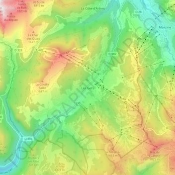
Name: Les Gets topographic map, elevation, terrain.
Average elevation: 4,462 ft
Minimum elevation: 2,743 ft
Maximum elevation: 7,028 ft
Make a donation
Gear up for your next adventure:
As an Amazon Associate, this site earns from qualifying purchases at no extra cost to you.
Other topographic maps
Click on a map to view its topography, its elevation and its terrain.
Val Thorens
France > Auvergne-Rhône-Alpes > Savoy
Val Thorens ([val tɔʁɑ̃]) is a ski town in the Tarentaise Valley in the French Alps at an altitude of 2,300 m (7,500 ft). It is located in the commune of Saint-Martin-de-Belleville in the Savoie department. The resort forms part of the Les Trois Vallées ski area which, with over 600 km of slopes, is one…
Average elevation: 8,255 ft
Make a donation
Gear up for your next adventure:
As an Amazon Associate, this site earns from qualifying purchases at no extra cost to you.
Les Gardes
France > Auvergne-Rhône-Alpes > Cantal > Saint-Jacques-des-Blats
Average elevation: 4,154 ft
Make a donation
Gear up for your next adventure:
As an Amazon Associate, this site earns from qualifying purchases at no extra cost to you.