
Thank you for supporting this site ❤️
Make a donation
Make a donation
Gear up for your next adventure:
As an Amazon Associate, this site earns from qualifying purchases at no extra cost to you.
Mazouna topographic map
Click on the map to display elevation.
Thank you for supporting this site ❤️
Make a donation
Make a donation
Gear up for your next adventure:
As an Amazon Associate, this site earns from qualifying purchases at no extra cost to you.
About this map
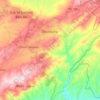
Name: Mazouna topographic map, elevation, terrain.
Location: Mazouna, Daïra Mazouna, Provincia de Relizan, Argelia (36.05740 0.84790 36.15802 0.94580)
Average elevation: 1,316 ft
Minimum elevation: 361 ft
Maximum elevation: 2,162 ft
Thank you for supporting this site ❤️
Make a donation
Make a donation
Gear up for your next adventure:
As an Amazon Associate, this site earns from qualifying purchases at no extra cost to you.