Geolocate

Lake View topographic map

Click on the map to display elevation.

About this map

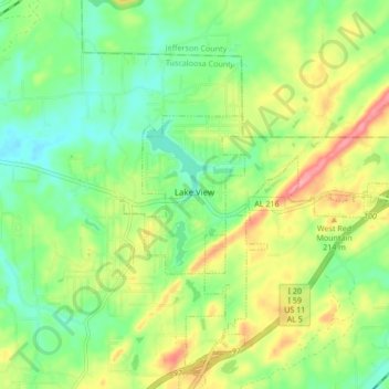
Name: Lake View topographic map, elevation, terrain.

Location: Lake View, Tuscaloosa County, Alabama, United States (33.26568 -87.15370 33.29468 -87.06887)

Average elevation: 571 ft

Minimum elevation: 440 ft

Maximum elevation: 774 ft

Tuscaloosa County trails, hiking, mountain biking, running and outdoor activities

Other topographic maps

Click on a map to view its topography, its elevation and its terrain.

Northport

United States > Alabama > Tuscaloosa County > Northport

Average elevation: 282 ft

Magnolia Park

United States > Alabama > Tuscaloosa County

Average elevation: 177 ft

Ridgeland

United States > Alabama > Tuscaloosa County > Tuscaloosa

Average elevation: 253 ft

Vance

United States > Alabama > Tuscaloosa County > Vance

Average elevation: 512 ft

The Summit

United States > Alabama > Tuscaloosa County > Northport

Average elevation: 226 ft

Cottondale

United States > Alabama > Tuscaloosa County > Tuscaloosa

Average elevation: 305 ft

Sand Mountain

United States > Alabama > Tuscaloosa County

Average elevation: 331 ft

Carolwood

United States > Alabama > Tuscaloosa County

Average elevation: 325 ft

Flatwoods

United States > Alabama > Tuscaloosa County > Northport

Average elevation: 253 ft

Pine Circle

United States > Alabama > Tuscaloosa County > Coker

Average elevation: 226 ft

Northport

United States > Alabama > Tuscaloosa County > Northport

Average elevation: 292 ft

Buhl

United States > Alabama > Tuscaloosa County > Buhl

Average elevation: 295 ft

Fosters

United States > Alabama > Tuscaloosa County > Fosters

Average elevation: 177 ft

Three Forks

United States > Alabama > Tuscaloosa County

Average elevation: 512 ft

Gear up for your next adventure:

🔦LED Headlamp - Bright and durable LED headlamp for night navigation
🎒Trail Energy Bars - High‑calorie bars for hiking energy
🗻Climbing Gear Basics - Essential gear for beginner climbers
🎒Gear Packing Cubes - Organize your backpack efficiently
🏫Relief Map Kits - Hands-on tools for teaching landforms and elevation

As an Amazon Associate, this site earns from qualifying purchases at no extra cost to you.