
Make a donation
Gear up for your next adventure:
As an Amazon Associate, this site earns from qualifying purchases at no extra cost to you.
Upli topographic map
Click on the map to display elevation.
Make a donation
Gear up for your next adventure:
As an Amazon Associate, this site earns from qualifying purchases at no extra cost to you.
About this map
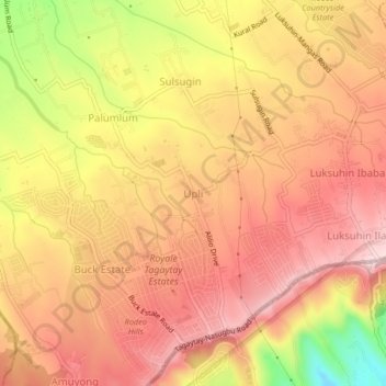
Name: Upli topographic map, elevation, terrain.
Location: Upli, Alfonso, Cavite, Calabarzon, 4123, Philippines (14.07136 120.84401 14.11136 120.88401)
Average elevation: 1,752 ft
Minimum elevation: 1,129 ft
Maximum elevation: 2,083 ft
Make a donation
Gear up for your next adventure:
As an Amazon Associate, this site earns from qualifying purchases at no extra cost to you.
Other topographic maps
Click on a map to view its topography, its elevation and its terrain.
Dasmariñas
Dasmariñas is partly lowland and partly hilly. The Poblacion itself is elevated. From an elevation of 80 meters (260 ft) at the Poblacion, the land rises to 250 meters (820 ft) towards Silang. Generally, land near rivers and creeks are rugged. Dasmariñas is outside the typhoon belt and has no fault line…
Average elevation: 413 ft
Trece Martires
The city of Trece Martires is characterised with ground elevation ranging from 30 metres (98 ft) to nearly 400 metres (1,300 ft). Its ground slope ranges from 0.5 to 2%.
Average elevation: 466 ft
Make a donation
Gear up for your next adventure:
As an Amazon Associate, this site earns from qualifying purchases at no extra cost to you.