
Make a donation
Gear up for your next adventure:
As an Amazon Associate, this site earns from qualifying purchases at no extra cost to you.
Guilin topographic map
Click on the map to display elevation.
Make a donation
Gear up for your next adventure:
As an Amazon Associate, this site earns from qualifying purchases at no extra cost to you.
Guilin
Guilin (Standard Zhuang: Gveilinz), formerly romanized as Kweilin, is a prefecture-level city in the northeast of China's Guangxi Zhuang Autonomous Region. It is situated on the west bank of the Li River and borders Hunan to the north. Its name means "forest of sweet osmanthus", owing to the large number of fragrant sweet osmanthus trees located in the region. The city has long been renowned for its scenery of karst topography.
Make a donation
Gear up for your next adventure:
As an Amazon Associate, this site earns from qualifying purchases at no extra cost to you.
About this map
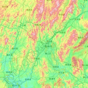
Name: Guilin topographic map, elevation, terrain.
Location: Guilin, Guangxi, China (24.26275 109.61164 26.38787 111.48759)
Average elevation: 1,549 ft
Minimum elevation: 213 ft
Maximum elevation: 6,713 ft
Make a donation
Gear up for your next adventure:
As an Amazon Associate, this site earns from qualifying purchases at no extra cost to you.
Other topographic maps
Click on a map to view its topography, its elevation and its terrain.