Geolocate

Stargard topographic map

Click on the map to display elevation.

About this map

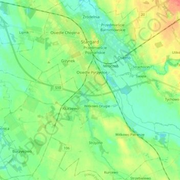
Name: Stargard topographic map, elevation, terrain.

Location: Stargard, Stargard County, West Pomeranian Voivodeship, Poland (53.25538 14.93850 53.36268 15.08474)

Average elevation: 98 ft

Minimum elevation: 49 ft

Maximum elevation: 187 ft

Gear up for your next adventure:

📡GPS Antenna Upgrade - Enhance GPS reception in remote terrain
🧥Men's Rain Shells - Premium waterproof and breathable jackets for mountain weather
🕶️GPS Smartphone Mount - Secure mount for phone navigation
🪶Thermal Camp Blanket - Extra warmth for cold nights
🔌Solar Panel Charger - Charge gear sustainably outdoors

As an Amazon Associate, this site earns from qualifying purchases at no extra cost to you.