
Make a donation
Gear up for your next adventure:
As an Amazon Associate, this site earns from qualifying purchases at no extra cost to you.
Cerro Challay topographic map
Click on the map to display elevation.
Make a donation
Gear up for your next adventure:
As an Amazon Associate, this site earns from qualifying purchases at no extra cost to you.
About this map
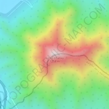
Name: Cerro Challay topographic map, elevation, terrain.
Average elevation: 2,336 ft
Minimum elevation: 1,270 ft
Maximum elevation: 4,104 ft
Make a donation
Gear up for your next adventure:
As an Amazon Associate, this site earns from qualifying purchases at no extra cost to you.
Other topographic maps
Click on a map to view its topography, its elevation and its terrain.
Laguna de Aculeo
Chile > Región Metropolitana de Santiago > Provincia de Maipo > Paine > Rincón del Álamo > Punta Gruesa
Average elevation: 1,201 ft
Laguna de Aculeo
Chile > Región Metropolitana de Santiago > Provincia de Maipo > Paine > Rincón del Álamo
Average elevation: 1,234 ft
Laguna de Aculeo
Chile > Región Metropolitana de Santiago > Provincia de Maipo > Paine > Rincón del Álamo
Average elevation: 1,234 ft