Geolocate

Boston topographic map

Click on the map to display elevation.

About this map

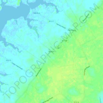
Name: Boston topographic map, elevation, terrain.

Location: Boston, Accomack County, Virginia, 23420, United States (37.58930 -75.86271 37.62930 -75.82271)

Average elevation: 20 ft

Minimum elevation: -7 ft

Maximum elevation: 46 ft

Accomack County trails, hiking, mountain biking, running and outdoor activities

Other topographic maps

Click on a map to view its topography, its elevation and its terrain.

Painter

United States > Virginia > Accomack County

It lies at an elevation of 36 feet.

Average elevation: 33 ft

Belle Haven

United States > Virginia > Accomack County

Average elevation: 26 ft

Folly Creek

United States > Virginia > Accomack County

Average elevation: 13 ft

Gear up for your next adventure:

🪶LED Camping Lantern - Bright lantern for camp lighting
Backpacking Tents - Weight-optimized shelters for multi-day topographic surveys
💧Water Purification System - Clean water on the trail with reliable purifiers
📻Weather Alert Radios - Stay informed of storm risks while off-the-grid
🔭Compact Binoculars - HD vision for scouting terrain and identifying distant landmarks

As an Amazon Associate, this site earns from qualifying purchases at no extra cost to you.