
Thank you for supporting this site ❤️
Make a donation
Make a donation
Gear up for your next adventure:
As an Amazon Associate, this site earns from qualifying purchases at no extra cost to you.
Pasirjambu topographic map
Click on the map to display elevation.
Thank you for supporting this site ❤️
Make a donation
Make a donation
Gear up for your next adventure:
As an Amazon Associate, this site earns from qualifying purchases at no extra cost to you.
About this map
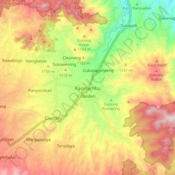
Name: Pasirjambu topographic map, elevation, terrain.
Location: Pasirjambu, Kabupaten Bandung, Java, 40972, Indonesia (-7.12886 107.44000 -7.04886 107.52000)
Average elevation: 3,743 ft
Minimum elevation: 2,608 ft
Maximum elevation: 4,757 ft
Thank you for supporting this site ❤️
Make a donation
Make a donation
Gear up for your next adventure:
As an Amazon Associate, this site earns from qualifying purchases at no extra cost to you.
Other topographic maps
Click on a map to view its topography, its elevation and its terrain.