
Thank you for supporting this site ❤️
Make a donation
Make a donation
Gear up for your next adventure:
As an Amazon Associate, this site earns from qualifying purchases at no extra cost to you.
Combia topographic map
Click on the map to display elevation.
Thank you for supporting this site ❤️
Make a donation
Make a donation
Gear up for your next adventure:
As an Amazon Associate, this site earns from qualifying purchases at no extra cost to you.
About this map
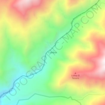
Name: Combia topographic map, elevation, terrain.
Location: Combia, Palmira, Sur, Valle del Cauca, RAP Pacífico, Colombia (3.66735 -76.05410 3.70735 -76.01410)
Average elevation: 8,241 ft
Minimum elevation: 6,591 ft
Maximum elevation: 10,397 ft
Thank you for supporting this site ❤️
Make a donation
Make a donation
Gear up for your next adventure:
As an Amazon Associate, this site earns from qualifying purchases at no extra cost to you.
Other topographic maps
Click on a map to view its topography, its elevation and its terrain.