
Thank you for supporting this site ❤️
Make a donation
Make a donation
Gear up for your next adventure:
As an Amazon Associate, this site earns from qualifying purchases at no extra cost to you.
Lavignino topographic map
Click on the map to display elevation.
Thank you for supporting this site ❤️
Make a donation
Make a donation
Gear up for your next adventure:
As an Amazon Associate, this site earns from qualifying purchases at no extra cost to you.
About this map
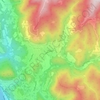
Name: Lavignino topographic map, elevation, terrain.
Location: Lavignino, Cheggino, Armeno, Novara, Piemonte, 28011, Italia (45.80170 8.42667 45.84170 8.46667)
Average elevation: 1,962 ft
Minimum elevation: 945 ft
Maximum elevation: 3,068 ft
Thank you for supporting this site ❤️
Make a donation
Make a donation
Gear up for your next adventure:
As an Amazon Associate, this site earns from qualifying purchases at no extra cost to you.