
Gutmaning topographic map
Click on the map to display elevation.
About this map
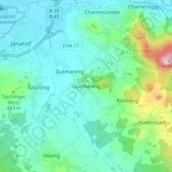
Name: Gutmaning topographic map, elevation, terrain.
Location: Gutmaning, Cham, Landkreis Cham, Bayern, 93413, Deutschland (49.17318 12.66941 49.21318 12.70941)
Average elevation: 1,352 ft
Minimum elevation: 1,198 ft
Maximum elevation: 1,942 ft
Other topographic maps
Click on a map to view its topography, its elevation and its terrain.
Schwedenschanze
Deutschland > Bayern > Landkreis Cham > Cham > Chammünster
Der Burgstall Schwedenschanze, bei der es sich vermutlich um die Reichsburg Cham handelt, ist eine abgegangene Höhenburg (Wallburg) auf dem 415 Meter hohen Galgenberg 35 Meter über dem Zusammenfluss von Chamb und Regen in der Gemarkung Altenstadt der Stadt Cham im oberpfälzischen Landkreis Cham in Bayern.…
Average elevation: 1,263 ft