
Thank you for supporting this site ❤️
Make a donation
Make a donation
Gear up for your next adventure:
As an Amazon Associate, this site earns from qualifying purchases at no extra cost to you.
Quillacollo topographic map
Click on the map to display elevation.
Thank you for supporting this site ❤️
Make a donation
Make a donation
Gear up for your next adventure:
As an Amazon Associate, this site earns from qualifying purchases at no extra cost to you.
About this map
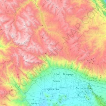
Name: Quillacollo topographic map, elevation, terrain.
Location: Quillacollo, Kanata, Quillacollo, Cochabamba, Bolivia (-17.46338 -66.46072 -17.04500 -66.22292)
Average elevation: 12,264 ft
Minimum elevation: 8,219 ft
Maximum elevation: 16,526 ft
Thank you for supporting this site ❤️
Make a donation
Make a donation
Gear up for your next adventure:
As an Amazon Associate, this site earns from qualifying purchases at no extra cost to you.