
Make a donation
Gear up for your next adventure:
As an Amazon Associate, this site earns from qualifying purchases at no extra cost to you.
Waterland-Oudeman topographic map
Click on the map to display elevation.
Make a donation
Gear up for your next adventure:
As an Amazon Associate, this site earns from qualifying purchases at no extra cost to you.
Waterland-Oudeman
Waterland-Oudeman ligt in het Meetjeslands krekengebied op een hoogte van ongeveer 2 meter. Het landschap wordt gekenmerkt door akkers, polderdijken en de Oudemanskreek.
Make a donation
Gear up for your next adventure:
As an Amazon Associate, this site earns from qualifying purchases at no extra cost to you.
About this map
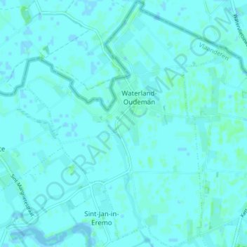
Name: Waterland-Oudeman topographic map, elevation, terrain.
Location: Waterland-Oudeman, Sint-Laureins, Eeklo, Oost-Vlaanderen, België (51.26302 3.55627 51.30595 3.61290)
Average elevation: 3 ft
Minimum elevation: -13 ft
Maximum elevation: 13 ft
Make a donation
Gear up for your next adventure:
As an Amazon Associate, this site earns from qualifying purchases at no extra cost to you.
Other topographic maps
Click on a map to view its topography, its elevation and its terrain.