
Make a donation
Gear up for your next adventure:
As an Amazon Associate, this site earns from qualifying purchases at no extra cost to you.
Morąg topographic map
Click on the map to display elevation.
Make a donation
Gear up for your next adventure:
As an Amazon Associate, this site earns from qualifying purchases at no extra cost to you.
About this map
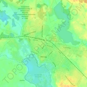
Name: Morąg topographic map, elevation, terrain.
Average elevation: 381 ft
Minimum elevation: 335 ft
Maximum elevation: 430 ft
Make a donation
Gear up for your next adventure:
As an Amazon Associate, this site earns from qualifying purchases at no extra cost to you.
Other topographic maps
Click on a map to view its topography, its elevation and its terrain.
Dylewska Góra
Poland > Warmian-Masurian Voivodeship > Ostróda County > Wysoka Wieś
Dylewska Góra (German: Kernsdorfer Höhe) is a hill located in northeastern Poland, south of the town of Ostróda, in the Warmian-Masurian Voivodeship. With elevation of 312 metres above sea level, it is one of the highest points of northern and central Poland. Dylewska Góra is a morainic hill, with its…
Average elevation: 883 ft
Szymanowo
Poland > Warmian-Masurian Voivodeship > Ostróda County > Nowy Dwór
Average elevation: 410 ft
Make a donation
Gear up for your next adventure:
As an Amazon Associate, this site earns from qualifying purchases at no extra cost to you.