
Thank you for supporting this site ❤️
Make a donation
Make a donation
Gear up for your next adventure:
As an Amazon Associate, this site earns from qualifying purchases at no extra cost to you.
Alcover topographic map
Click on the map to display elevation.
Thank you for supporting this site ❤️
Make a donation
Make a donation
Gear up for your next adventure:
As an Amazon Associate, this site earns from qualifying purchases at no extra cost to you.
About this map
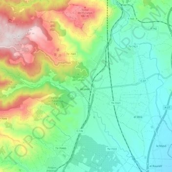
Name: Alcover topographic map, elevation, terrain.
Location: Alcover, Alt Camp, Tarragona, Catalonia, Spain (41.22348 1.09847 41.30543 1.21558)
Average elevation: 1,086 ft
Minimum elevation: 308 ft
Maximum elevation: 2,746 ft
Thank you for supporting this site ❤️
Make a donation
Make a donation
Gear up for your next adventure:
As an Amazon Associate, this site earns from qualifying purchases at no extra cost to you.
Other topographic maps
Click on a map to view its topography, its elevation and its terrain.
Tossal de la Serra del Mas de Gomis
Spain > Catalonia > Alt Camp > Alcover
Average elevation: 2,169 ft